Introduction to geographic phenomena
- Geographic phenomena is the events that takes place in geographic space and time
- Geographic phenomena is defined as something which is of interest in GIS application that have following characteristics:
1. It can be named or described.
2. It can be geo-referenced.
3. It can be assigned a time interval at which it is present.
- It implies the computerized representation of the geographic data.
- The representation is based on types of available data and types of data manipulation needed.
- For example: Consider a water management GIS system. The objects of study can be river, ground water level, irrigation level and so on. These objects can be named, geo-referenced and provided with time interval at which they exists. So, these objects are termed as geographic phenomena.
Types of Geographic Phenomena
- Geographic phenomena is classified into two categories. They are as follows:
1. Geographic Fields
2. Geographic Objects
Geographic fields and objects
Geographic Fields
- A geographic field is a geographic phenomena whose value at every point in the study area can be determined.
- If (x,y) represents the study area, then f(x,y) represents the value of the geographic field at that point.
- A geographic field can be discrete or continuous.
- The changes in the field values are gradual.
- The continuous field can be differentiated.
- The discrete field divide the study area in mutually exclusive and bounded parts, with all locations in a single part having same field value.
- The natural geographic phenomena are generally geographic fields.
- Eg: temperature, elevation and so on.
Geographic Objects
- A geographic object is a geographic phenomena whose value is determined only at certain points in the study area.
- It represents well distinguishable discrete entities.
- In between the geographic objects, there is presence of empty spaces.
- The position of geographic object is determined by a combination of one or more parameters such as location, shape, size and orientation.
- The artificial geographic phenomena are generally geographic objects.
- Eg: building, road, temple and so on.
Geographic boundaries
- Geographic boundary is defined as the notion that separates the two or more contiguous regions or geographic phenomena.
- With the knowledge of geographic boundary, it is possible to determine the location, shape and size of the area or region or geographic phenomena.
Types of Boundaries:
1. Crisp Boundary:
- It is the boundary that can be determined with arbitrary precision.
- It depends on the method of data acquisition used.
- It is common in geographic objects.
2. Fuzzy Boundary:
- It is the boundary that represents the area of transition.
- It is common in geographic fields.
spatial relationships and topology
- Topology is defined as the spatial relationship between geographic features.
- It has three components:
1. Connectivity
2. Containment
3. Contiguity
Connectivity
- The arcs are connected to others at nodes.
- It identifies possible routes and networks via a list of arcs and nodes in the database.
Containment
- It refers to the measurable area contained by an enclosed polygon.
- The list of arcs defines the boundaries and closed areas.
Contiguity
- It refers to the shared arcs between the adjacent polygons.
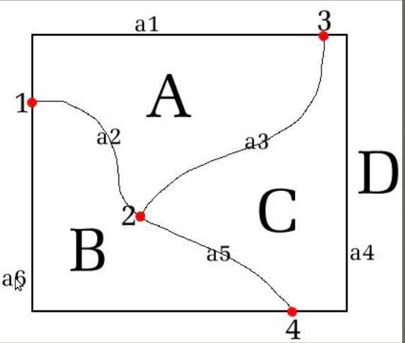
Types of Topology
1. Arc Topology
2. Node Topology
3. Polygon Topology
In the given figure,
- a1, a2, a3, a4, a5 and a6 represents arc topology.
- 1, 2, 3 and 4 represents node topology.
- A, B, C and D represents polygon topology.
vector, raster and digital terrain model
Data Models
- In the real world, the geographic variation is complex, which can not be accurately modeled in the computerized GIS system.
- Data models provide a set of rules that convert real geographic variation into discrete objects.
- It provides guidelines on how to organize the geographic variation data into a logical data that fits in the database.
- It preserves the unit of data as a discrete objects and the relationships between them.
- The real world is simplified into three spatial elements. They are point, line and area or surface.
- There are two types of data models. They are as follows:
1. Raster Model
2. Vector Model
Raster Model:
- Raster model makes use of the raster data.
- It is based on pixels and consists of a regular grid structure of rows and columns.
- This model attempts to divide the real world into a regular grid of identically shaped cells.
- Each cell represents a single value for the whole area of that cell. It means features within the cell is assumed to be homogeneous.
- The resolution of the model is based on the grid size i.e. smaller the cell, higher the resolution.
- Storage necessary for the data increases with the square of the resolution.
Advantages:
1. It uses simple data structure.
2. The overlay operations are straight forward.
3. The spatial variation is efficiently represented.
Disadvantages:
1. Data structure is not compact.
2. It is hard to represent topological relationships.
3. The map output may appear as a block.
Vector Model:
- Vector model is based on objects like point, line and area.
- Every point has a unique location.
- An object shape is represented by dots which are located at the location where the shape of the object changes.
- The database holds data about vertex, arc and polygon which are uniquely identified at each point and the relationships between them.
- The vector data are stored as a series of linked files establishing explicit spatial topography.
- Resolution is independent of the details present.
Advantages:
1. Compact data structure for homogeneous areas.
2. It makes use of topology or spatial relationships.
3. It provides efficient map output.
Disadvantages:
1. The data structure used is more complex.
2. The overlay operations are complex.
3. It can not store continuously varying image data.
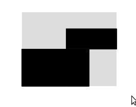
Tessellation
- A tessellation is defined as a partition of the space into mutually exclusive cells that together make up the complete study space.
- It is generally used to represent geographic fields.
- It is of two types : regular and irregular.
Regular tessellation:
- It makes use of only one type of regular polygon such that there is no overlapping and each vertex looks the same.
- Triangles, squares and hexagons can form regular tessellation but pentagons and heptagons can not.
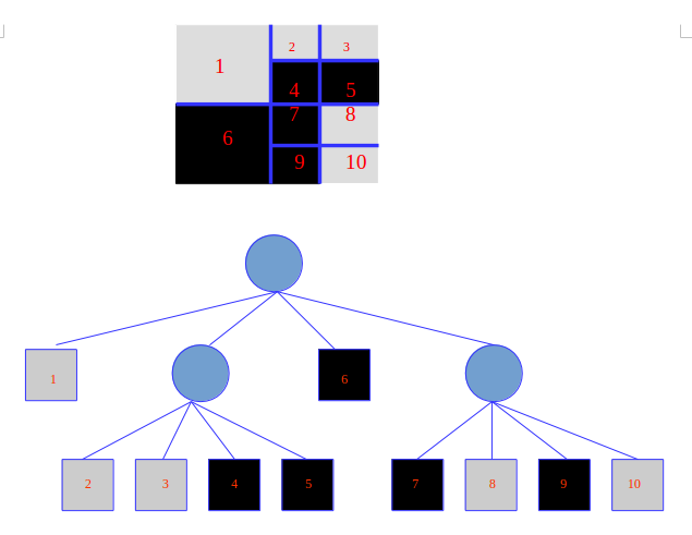
Irregular tessellation:
- It makes use of one type of regular polygon but the polygon size and shape may vary, allowing the adaptation to the spatial phenomena.
- It reduces the amount of memory used to store the data.
- A well known approach is region quad tree, which is based on regular tessellations of square cells.
- In memory, the nodes of quadtree are represented as records.
Solved Problem (2068 Chaitra)
Q. Represent the given geo-phenomena using irregular tesselation.
Solution:
Using the quad tree approach as shown in given figure:
Digital Elevation Model (DEM) or Digital Terrain Model (DTM)
- It is the surface representation of the geography.
- It represents the digital geographic data of elevations in terms of x, y and z coordinates.
- Digital Elevation Models (DEMs) are the generally adopted data structures for storing topographic information and are usually interpolated to establish the values for entire terrain points.
- The terrain elevations for ground positions are sampled at regularly spaced horizontal intervals.
- Terrain is represented by contours which is continuously varying.
- It only stores data at the regularly spaced intervals. Between these intervals the values are calculated by the process of interpolation.
- Interpolation techniques are based on the principles of spatial autocorrelation, which assumes that the closer points are more similar than the farther ones.
- The various interpolation methods used are as follows:
1. Inverse Distance Weighting (IDW)
2. Nearest Neighbour (NN)
3. Kriging
4. Spline Interpolation
Kriging:
- It is a geo statistical interpolation method that utilizes variogram which depends on the spatial distribution of data rather than on actual values.
- Kriging weights are derived using a data driven weighting function to reduce the bias toward input values.
- It provides the best interpolation when good variogram models are available.
Inverse Distance Weighting
- It is a local deterministic interpolation technique that calculates the value as a distance weighted average of sampled points in a defined neighborhood.
- It considers that points closer to the query location will have more influence and weights the sample points with inverse of their distance from the required points.
Nearest Neighbor
- It finds the closest subset of input samples to a query point and applies weight to them based on proportionate areas.
- It is local deterministic method and interpolated heights are guaranteed to be within the range of the samples used.
- It works well for both regularly as well as irregularly distributed data.
Spline Interpolation
- The Spline interpolation approach uses mathematical function to minimize the surface curvature and produces a smooth surface that exactly fits the input points.
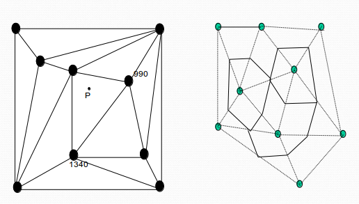
Triangular Irregular Network (TIN)
- It is one of the standard implementation for the digital terrain model.
- An irregularly spaced sample points can be adapted to the terrain with more points in the area of rough terrain and few points in smooth terrain.
- The sample points are connected by the lines to form triangles.
- Within each triangle, the surface is represented by a plane.
- The use of triangles guarantees each piece of mosaic surface will fit with its neighboring pieces.
- Each triangle's surface is defined by the elevations of the three corner points.
Spatial database design with the concepts of geodatabase
Spatial Database
- A spatial database is a database system that supports spatial data types in its data model and query language providing spatial indexing and spatial joins.
- It consists of a collection of spatially referenced data that acts as a model of reality by representing the approximation of the geographic phenomena.
Geo-Database
- Geo-Database is a geographic data format based on object oriented model.
- It is generally a relational database management system that supports topologically integrated feature classes.
- The users are allowed to add behaviors, properties, rules and relationships to the data.
- It maintains data integrity.
- It has .gdb extension.
- It is able to hold datasets tying together the spatial features with the attributes.
-
Types of Geo Database
1. Personal Geo Database
- It is a stand alone single user geo database.
- It supports datasets up to 2 GB.
- It is implemented as a Microsoft Access database (.mdb file).
- It is generally used for personal or small work-group use.
2. File Geo Database
- All the files are stored in a file system.
- It supports geo database with datasets up to 1 TB.
3. Enterprise Geo Database
- It exists on the underlying RDBMS through Spatial Database Engine.
- It usually runs on a dedicated server.
- It supports many users and massive datasets.
- It also supports raster datasets.
Elements of Geo Database
1. Objects and Object Class
2. Feature and Feature Class
3. Feature Dataset
4. Spatial Reference
5. Domain
6. Subtype
7. Relationship and Relationship Class
8. Geometric Network
9. Label and Annotation
- The geographic data is arranged into a hierarchy of data objects.
- Object has properties and behavior.
- Each object has unique identifier called OID.
- Object class is represented by table that store non-spatial data.
- Objects are related via relationships.
- Features are objects that represent a real world object.
- Feature class is a collection of features with similar geometry and attributes.
- Feature class is an object class that stores spatial objects.
- Feature dataset is a container for the feature classes sharing spatial reference.
Building a Geo Database
It involves following steps:
1. Design Geo Database (Conceptual plan and logical design)
2. Create new Geo Database
3. Define Geo Database Structure (Manually from scratch, Importing existing schema, Using CASE tools and UML)
4. Entering Spatial Data
5. Define Additional Properties (Validation rule, topological structure, annotations)

Ⓒ Copyright ESign Technology 2019. A Product of ESign Technology. All Rights Reserved.