SDI concepts and its current trend
Spatial Data Infrastructure
- SDI is defined as the collection of technologies, policies and institutional arrangements that facilitates the availability and access to spatial data.
- It provides basis for spatial data discovery, evaluation and application for users and providers.
- It encompasses resources, systems, network linkage, standards and institutional issues involved from many different sources in delivering the geo-spatial information to the potential users.
- The main aim of SDI can be expressed as follows:
1. To link existing and upcoming databases of the respective level. (Represented by product based model)
2. To define a framework to facilitate the management of information assets. (Represented by process based model)
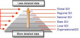
SDI Hierarchy
- The SDI hierarchy consists of following levels:
1. Organizational SDI
2. Local SDI
3. State SDI
4. National SDI
5. Regional SDI
6. Global SDI
- Organizational, local and state SDI are the operational levels of the SDI.
- National SDI is the functional level of SDI.
- Regional and Global SDI are the strategy management level of the SDI.
- Each lower level provides the building block for upper levels.
- Each upper level transfers strategy and policy to lower levels.
National Spatial Data Infrastructure (NSDI)
- It is the functional level of Spatial Data Infrastructure that encourages collection, processing, archiving, integration and sharing of the geographic spatial data and information using common standards and inter-operable system and techniques.
- It assures that the spatial data from multiple sources are widely available and integrated to enhance knowledge and understanding of the geographic phenomena of the world.
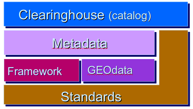
Components of SDI
- The basic components of SDI are as follows:
1. Standards
2. Framework
3. Geo-data
4. Metadata
5. Clearing House
Characteristics of SDI
1. It is a set of base capabilities.
2. It is a general comprehensive system.
3. It has multiple effective aspects in ICT utilization.
4. It includes stable and dynamic physical components.
5. It provides fundamental, important and irreplaceable services
The concept of metadata and clearing house
Clearing House
- A clearing house is a distributed network of spatial data producers, managers and users that are linked together electronically.
- It consists of a system of software and institutions that facilitates discovery, evolution and transfer of the spatial data.
- The main aim of the clearing house is to minimize unnecessary duplication of the effort for data capture and to maximize the benefit of geographic information sharing.
- It acts as a service that supports for links to the spatial data and browsing capabilities.
- From institutional point of view, it is the people and infrastructure that facilitates discovery of which geographic information is possessed by whom.
- From technical point of view, it is the information service that provides access to the geographic information for the potential users.
Working of Data Clearing House
- The data providers are allowed to register their geographic data sets, quality of data and methods to access these data.
- The data providers also provides additional information about the data sets.
- Client consults server registry to get the geographic data access.
- The registry pass the distributed query to all the data servers.
- The data servers provide response in the form of headlines.
- Client request metadata entry.
- Metadata or data are downloaded or a connection to the data is made.
Metadata
- Metadata is the additional information about the data sets, which describes content, quality, condition and other characteristics of the data.
- It provides a way to inform the potential users about the data sets, their purpose and scope.
- It is used internally by the data provider to monitor the status of the data sets.
- It is used externally to advertise to the potential users through a national clearing house.
- A standard is defined for the design of the metadata.
- Metadata must be managed properly to keep it up-to-date.
Role of Metadata
1. Availability (information needed to determine the data sets that exists for a geographic locations)
2. Fitness for use (information needed to determine whether a data set meets a specified need)
3. Access (information needed to acquire and access the data set)
4. Transfer (information needed to process and use the data sets)
Critical factors around SDIs
1. Data Standards
- It refers to the agreed way of representing data in a system in terms of content, type and format.
- The same data standard should be maintained by the databases so as to successfully exchange data between them.
- So, a common data standard should be formulated supporting common data architecture to provide efficient base for data transfer.
2. Heterogeneity
- Spatial data are heterogeneous in nature. It means the data differ in kind, quality and character.
- Such heterogeneous data are maintained by a variety of database system.
- This creates inconsistency among data sets and creates problems during data sharing.
3. Communication Problem
- Spatial data is huge in size.
- The problem in communication technology is to select the appropriate technology to transfer such huge data with security and reliability.
- The communication medium must guarantee efficiency in search and delivery of the spatial data.
4. Institutional and Economic Problems
- It arises due to the absence of policy for pricing, copyright, privacy, liability, quality and so on.
- For the proper data sharing, such problems should be resolved.

Ⓒ Copyright ESign Technology 2019. A Product of ESign Technology. All Rights Reserved.