Introduction of open concept in GIS
Open GIS
- OpenGIS is the ability to share heterogeneous geodata and geoprocessing resources transparently in a networked environment.
Why OpenGIS?
1. Extends open system benefits to GIS.
2. Achieve inter-operability between system, data and functionality
3. Establish common language and unified model for geographic information
Benefits of OpenGIS
1. It allows integration with computing standards.
2. It provides quick and efficient development cycles.
3. It avoids data transfer redundancies.
Open GIS Consortium (OGC)
- OGC is an international voluntary consensus standard organization that enforce collaboration in a consensus process encouraging development and implementation of open standards for geospatial contents and services, GIS data processing and data sharing.
- OGC has three operational units. They are as follows:
1. Specification program
2. Interoperability program
3. Outreach and Community adoption
OGC Standards
- The OGC standards depend on a generalized architecture captured in a set of documents known as Abstract specification.
- Abstract specification is the document that describes a basic data model for representing geographic features.
- The OGC standards baseline comprises more than 30 standards including GML (Geography Markup Language), CSW (Catalog Service for the Web), OLS (Open Location Service), SOS (Sensor Observation Service) and so on.
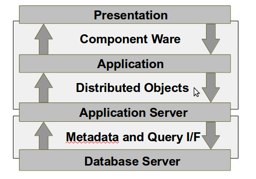
Architectural Layers of GIS
The architectural layers of GIS is shown in given figure:
Open source software for spatial data analysis
1. ClusterPy
- It is a non-GUI open source software for spatial data analysis.
- The field of interest is spatial clustering.
- It provides library to aggregate areas into regions.
2. Google Earth
- The field of interest is 3D visualization.
- It provides easy to use, dynamic graphics and historical maps, with which the users can create dynamic tours.
3. QGIS
- The field of interest is visualization.
- It provides easy to use interface and geoprocessing functions.
- It allows users to expand functionalities with Python plugins.
4. GRASS
- The field of interest is GIS.
- It provides extensive set of GIS tools for both raster and vector data, SQL, visualization and voxel.
Overview of OpenStreetMap
- OpenStreetMap is a collaborative project aimed to create and provide free geographic data such as street maps to anyone who wants those data.
- It was started so as to make people unrestricted in use of geographic data or maps in creative, productive and unexpected way.
- It helps to create a free editable map of the world.
- Volunteers collect data using manual survey, GPS, or other free sources. These data are then made available under the Open Database Licence on the official website. The website is supported by a non profit organization known as OpenStreetMap Foundation.
- The data generated is considered to be the primary output of OpenStreetMap project, which is available for use in different applications.
- The data collection is the first phase of the project.
- In the second phase, editing takes place using one of several purpose-built map editors like JSOM. This is done generally by the one who collects the data.
Map Usage
- The data provided by the OpenStreetMap can be viewed in a web browser with JavaScript support via HTTP on its official website.
Data Format
- OpenStreetMap uses a topological data structure with four core elements:
1. Nodes
2. Ways
3. Relations
4. Tags
- Nodes are points with a geographic position, stored as coordinates according to WGS 84.
- Ways are ordered list of nodes used for representing linear features.
- Relations are ordered list of nodes, ways and relations, which are used for representing the relationship of existing nodes and ways. Eg: turn restrictions on roads and so on.
- Tags are key-value pairs used to store metadata about the map objects. It is always attached to an object of a map.
Web Based GIS system
- Web based GIS system is the system that allows dissemination, sharing, displaying and processing spatial information on the Internet.
- It provides a low cost and efficient way to deliver map products to the users.
- It is a way to access the the spatial data easily and efficiently for various GIS operations such as advanced mapping and spatial analysis over the Internet.
Advantages of Web GIS
1. Planning and design support
2. Export of existing base map data to CAD system
3. Performance analysis
4. Adequate management of materials
5. Efficient operation
6. Quick response to customer's inquiry
Examples of Web GIS
- Google Earth
- Google Maps
- iMapper
- Map-TV
- AspMap
- ArcGIS Server
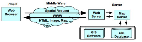
Web GIS Architecture
- Client side consists of a web browser.
- Server side consists of web server, web GIS software and database.
- Server runs the GIS software and a client GIS interface is added to the client side.
- Server side also consists of a middleware that allows communication between GIS at server and client GIS interface.
Web GIS Development Cycle
1. Requirement Analysis
- It involves determining the requirements for the GIS application.
- It is performed by interviewing the potential users.
- It produces information related to functionality needed and data necessary.
2. Conceptual Design
- The data model is designed that identifies the entities and their relationships.
- The appropriate architecture is determined.
3. Survey of Available Software and Hardware
- With respect to the required functions, the hardware and software necessary for the GIS application design are chosen.
- Web GIS typically requires specific hardware configuration.
4. Database Design and Construction
- It involves how the geographic data will be represented and mapped into the database.
- It consists of following steps:
a) Selecting source for each entity and attribute present in ER diagram.
b) Setting up logical database design
c) Define way to convert data from source to the database
d) Define way to manage and maintain the database.
5. Acquisition of GIS Hardware and Software
- The specific GIS hardware and software specified are acquired.
6. Web GIS system Integration
- The different hardware and software components are integrated and tested to confirm that the system provides the necessary functionality as required.
7. Application Development
- The user interface for client side is developed.
- It must be easy to use, user friendly and data transfer reduction design.
8. Use and Maintenance
- The system is then put into use for potential users.
- The system should be maintained timely for Web GIS to run smoothly.
- User feedback are collected to determine the need of new functionalities.

Ⓒ Copyright ESign Technology 2019. A Product of ESign Technology. All Rights Reserved.